Monday, 15 October 2018

Petra

Petra


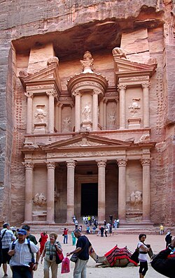
Petra Jordan BW 21.JPG

Petra (Arabic: البتراء, Al-BatrāʾAncient Greek: Πέτρα), originally known to its inhabitants as Raqmu, is a historical and archaeological city in southern Jordan. Petra lies on the slope of Jabal Al-Madbah in a basin among the mountains which form the eastern flank of Arabah valley that run from the Dead Sea to the Gulf of Aqaba. According to Hieronymus of Cardia, the name "Petra" was given by Greek merchants, who observed the city's inhabitants offering sacrifice, in springtime, to a deity on a large stone, i.e. petra. Petra is believed to have been settled as early as 9,000 BC, and it was possibly established in the 4th century BC as the capital city of the Nabataean Kingdom. The Nabataeans were nomadic Arabswho invested in Petra's proximity to the trade routes by establishing it as a major regional trading hub.
The trading business gained the Nabataeans considerable revenue and Petra became the focus of their wealth. The earliest historical reference to Petra was the attack to the city ordered by Antigonus I in 312 BC recorded by various Greek historians. The Nabataeans were, unlike their enemies, accustomed to living in the barren deserts, and were able to repel attacks by utilizing the area's mountainous terrain. They were particularly skillful in harvesting rainwateragriculture and stone carving. Most of the Nabataean rulers embraced Greek culture, first of which was Aretas III Philhellen (87-62 BC), up to the last Nabataean ruler, Rabbel II Soter (70-106 AD). Petra flourished in the 1st century AD when its famous Khazneh structure –believed to be the mausoleum of Nabataean King Aretas IV– was constructed using Greek architectural elements, and its population peaked at an estimated 20,000 inhabitants.
Although the Nabataean Kingdom became a client state for the Roman Empire in the first century BC, it was only in 106 AD that they lost their independence. Petra fell to the Romans who annexed and renamed Nabataea to Arabia Petraea. Petra's importance declined as sea trade routes emerged, and after a 363 earthquake destroyed many structures. The Byzantine Era witnessed the construction of several Christian churches, but the city started to decline after attacks due to the emerging Sasanid Empire, and by the early Islamic era became an abandoned place where only a handful of nomads lived. It remained unknown to the world until it was rediscovered in 1812 by Johann Ludwig Burckhardt.
The city is accessed through a 1.2 kilometres (0.75 mi) long gorge called the Siq, which leads directly to the Khazneh. Famous for its rock-cut architecture and water conduit system, Petra is also called the Rose City due to the color of the stone out of which it is carved. It has been a UNESCO World Heritage Site since 1985. UNESCO has described it as "one of the most precious cultural properties of man's cultural heritage". In 2007, Al-Khazneh was voted in as one of the New7Wonders of the World. Petra is a symbol of Jordan, as well as Jordan's most-visited tourist attraction. Tourist numbers peaked at 1 million in 2010, the following period witnessed a slump due to regional instability. However, tourist numbers have picked up recently, and around 600,000 tourists visited the site in 2017.

LocationMa'an GovernorateJordan
Coordinates30°19′43″N 35°26′31″ECoordinates30°19′43″N 35°26′31″E
Area264 square kilometres (102 sq mi)[1]
Elevation810 m (2,657 ft)
Builtpossibly as early as 5th century BC [2]
Visitors596,602 (in 2014)
Governing bodyPetra Region Authority
Websitewww.visitpetra.jo
Petra is located in Jordan

Colosseum

Colosseum

Colosseum in Rome, Italy - April 2007.jpg

Colosseum is situated just east of the Roman Forum. Construction began under the emperor Vespasian in AD 72, and was completed in AD 80 under his successor and heir Titus.[3]Further modifications were made during the reign of Domitian (81–96). These three emperors are known as the Flavian dynasty, and the amphitheatre was named in Latinfor its association with their family name (Flavius).
The Colosseum could hold, it is estimated, between 50,000 and 80,000 spectators, having an average audience of some 65,000; it was used for gladiatorial contests and public spectacles such as mock sea battles (for only a short time as the hypogeumwas soon filled in with mechanisms to support the other activities), animal hunts, executions, re-enactments of famous battles, and dramas based on Classical mythology. The building ceased to be used for entertainment in the early medievalera. It was later reused for such purposes as housing, workshops, quarters for a religious order, a fortress, a quarry, and a Christian shrine.
Although partially ruined because of damage caused by earthquakes and stone-robbers, the Colosseum is still an iconic symbol of Imperial Rome and is listed as one of the New7Wonders of the World. It is one of Rome's most popular tourist attractions and also has links to the Roman Catholic Church, as each Good Fridaythe Pope leads a torchlit "Way of the Cross" procession that starts in the area around the Colosseum.

LocationRegio IV Templum Pacis ("Temple of Peace")
Built in70–80 AD
Built by/forVespasianTitus
Type of structureAmphitheatre
RelatedList of ancient monuments
in Rome
The Colosseum is located in Rome

Forbidden City

 Forbidden City

Forbidden City Beijing Shenwumen Gate.JPG

The Forbidden City is a palacecomplex in central Beijing, China. The former Chinese imperial palace from the Ming dynasty to the end of the Qing dynasty (the years 1420 to 1912), it now houses the Palace Museum. The Forbidden City served as the home of emperors and their households as well as the ceremonial and political center of Chinese government for almost 500 years.
Constructed from 1406 to 1420, the complex consists of 980 buildingsand covers 72 hectares (over 180 acres). The palace exemplifies traditional Chinese palatial architecture and has influenced cultural and architectural developments in East Asia and elsewhere. The Forbidden City was declared a World Heritage Site in 1987, and is listed by UNESCO as the largest collection of preserved ancient wooden structures in the world.
Since 1925, the Forbidden City has been under the charge of the Palace Museum, whose extensive collection of artwork and artifacts were built upon the imperial collections of the Ming and Qing dynasties. Part of the museum's former collection is now in the National Palace Museum in Taipei. Both museums descend from the same institution, but were split after the Chinese Civil War. Since 2012, the Forbidden City has seen an average of 15 million visitors annually, and received more than 16 million visitors in 2016 and 2017.

Established1925
Location4 Jingshan Front St, DongchengBeijing, China
Coordinates39.915987°N 116.397925°ECoordinates39.915987°N 116.397925°E
TypeArt museum, Imperial Palace, Historic site
Visitors16.7 million[1]
Ranking 1st globally
CuratorShan Jixiang (单霁翔)
Built1406–1420
ArchitectKuai Xiang
Architectural style(s)Chinese architecture
Websiteen.dpm.org.cn (English language version)
www.dpm.org.cn (Chinese language version)
UNESCO World Heritage site
Part ofImperial Palaces of the Ming and Qing Dynasties in Beijing and Shenyang
CriteriaCultural: i, ii, iii, iv
Reference439-001
Inscription1987 (11th Session)

Machu Picchu

Machu Picchu


The site is roughly divided into an urban sector and an agricultural sector, and into an upper town and a lower town. The temples are in the upper town, the warehouses in the lower.
The architecture is adapted to the mountains. Approximately 200 buildings are arranged on wide parallel terraces around an east-west central square. The various compounds, called kanchas, are long and narrow in order to exploit the terrain. Sophisticated channeling systems provided irrigation for the fields. Stone stairways set in the walls allowed access to the different levels across the site. The eastern section of the city was probably residential. The western, separated by the square, was for religious and ceremonial purposes. This section contains the Torreón, the massive tower which may have been used as an observatory.
Located in the first zone are the primary archaeological treasures: the Intihuatana, the Temple of the Sun and the Room of the Three Windows. These were dedicated to Inti, their sun god and greatest deity.
The Popular District, or Residential District, is the place where the lower-class people lived. It includes storage buildings and simple houses.
The royalty area, a sector for the nobility, is a group of houses located in rows over a slope; the residence of the amautas (wise persons) was characterized by its reddish walls, and the zone of the ñustas (princesses) had trapezoid-shaped rooms. The Monumental Mausoleum is a carved statue with a vaulted interior and carved drawings. It was used for rites or sacrifices.
The Guardhouse is a three-sided building, with one of its long sides opening onto the Terrace of the Ceremonial Rock. The three-sided style of Inca architecture is known as the wayrona style.
In 2005 and 2009, the University of Arkansas made detailed laser scans of the entire site and of the ruins at the top of the adjacent Huayna Picchu mountain. The scan data is available online for research purposes.

LocationCuzco RegionPeru
Coordinates13°09′48″S 72°32′44″WCoordinates13°09′48″S 72°32′44″W
Height2,430 metres (7,970 ft)
History
Foundedc. 1450
Abandoned1572
CulturesInca civilization
Site notes
ArchaeologistsHiram Bingham
Official nameHistoric Sanctuary of Machu Picchu
TypeMixed
Criteriai, iii, vii, ix
Designated1983 (7th session)
Reference no.274
State Party Peru
RegionLatin America and the Caribbean

Great Wall of China

Great Wall of China

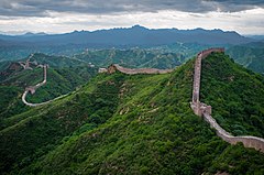
The Great Wall of China at Jinshanling-edit.jpg

The Great Wall of China is a series of fortifications made of stone, brick, tamped earth, wood, and other materials, generally built along an east-to-west line across the historical northern borders of China to protect the Chinese states and empiresagainst the raids and invasions of the various nomadic groups of the Eurasian Steppe with an eye to expansion. Several walls were being built as early as the 7th century BC; these, later joined together and made bigger and stronger, are collectively referred to as the Great Wall.Especially famous is the wall built in 220–206 BC by Qin Shi Huang, the first Emperor of China. Little of that wall remains. The Great Wall has been rebuilt, maintained, and enhanced over various dynasties; the majority of the existing wall is from the Ming Dynasty (1368–1644).
Apart from defense, other purposes of the Great Wall have included border controls, allowing the imposition of duties on goods transported along the Silk Road, regulation or encouragement of trade and the control of immigration and emigration. Furthermore, the defensive characteristics of the Great Wall were enhanced by the construction of watch towers, troop barracks, garrison stations, signaling capabilities through the means of smoke or fire, and the fact that the path of the Great Wall also served as a transportation corridor.
The frontier walls built by different dynasties have multiple courses. Collectively, they stretch from Dandong in the east to Lop Lake in the west, from present-day Sino-Russian border in the north to Qinghai in the south; along an arc that roughly delineates the edge of Mongolian steppe. A comprehensive archaeological survey, using advanced technologies, has concluded that the walls built by the Ming dynasty measure 8,850 km (5,500 mi). This is made up of 6,259 km (3,889 mi) sections of actual wall, 359 km (223 mi) of trenches and 2,232 km (1,387 mi) of natural defensive barriers such as hills and rivers. Another archaeological survey found that the entire wall with all of its branches measures out to be 21,196 km (13,171 mi). Today, the Great Wall is generally recognized as one of the most impressive architectural feats in history.

General information
TypeFortification
CountryChina
Coordinates40.68°N 117.23°EE
Technical details
Size21,196 km (13,171 mi)[1]
Official nameThe Great Wall
TypeCultural
Criteriai, ii, iii, iv, vi
Designated1987 (11th session)
Reference no.438
State PartyChina
RegionAsia-Pacific


Golden Gate Bridge

Golden Gate Bridge 

GoldenGateBridge-001.jpg

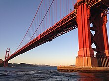
The Golden Gate Bridge is a suspension bridge spanning the Golden Gate, the one-mile-wide (1.6 km) strait connecting San Francisco Bay and the Pacific Ocean. The structure links the American city of San FranciscoCalifornia – the northern tip of the San Francisco Peninsula – to Marin County, carrying both U.S. Route 101 and California State Route 1across the strait. The bridge is one of the most internationally recognized symbols of San Francisco, California, and the United States. It has been declared one of the Wonders of the Modern World by the American Society of Civil Engineers.
The Frommer's travel guide describes the Golden Gate Bridge as "possibly the most beautiful, certainly the most photographed, bridge in the world."[8][9] At the time of its opening in 1937, it was both the longest and the tallest suspension bridge in the world, with a main span of 4,200 feet (1,280 m) and a total height of 746 feet (227 m).

Design

South tower seen from walkway, with Art Deco elements
Strauss was chief engineer in charge of overall design and construction of the bridge project.However, because he had little understanding or experience with cable-suspension designs,[22]responsibility for much of the engineering and architecture fell on other experts. Strauss's initial design proposal (two double cantilever spans linked by a central suspension segment) was unacceptable from a visual standpoint. The final graceful suspension design was conceived and championed by Leon Moisseiff, the engineer of the Manhattan Bridge in New York City.
Irving Morrow, a relatively unknown residential architect, designed the overall shape of the bridge towers, the lighting scheme, and Art Deco elements, such as the tower decorations, streetlights, railing, and walkways. The famous International Orange color was originally used as a sealant for the bridge. The US Navy had wanted it to be painted with black and yellow stripes to ensure visibility by passing ships.
Senior engineer Charles Alton Ellis, collaborating remotely with Moisseiff, was the principal engineer of the project. Moisseiff produced the basic structural design, introducing his "deflection theory" by which a thin, flexible roadway would flex in the wind, greatly reducing stress by transmitting forces via suspension cables to the bridge towers. Although the Golden Gate Bridge design has proved sound, a later Moisseiff design, the original Tacoma Narrows Bridge, collapsed in a strong windstorm soon after it was completed, because of an unexpected aeroelastic flutter. Ellis was also tasked with designing a "bridge within a bridge" in the southern abutment, to avoid the need to demolish Fort Point, a pre–Civil War masonry fortification viewed, even then, as worthy of historic preservation. He penned a graceful steel arch spanning the fort and carrying the roadway to the bridge's southern anchorage.
Below Golden Gate Bridge
Ellis was a Greek scholar and mathematician who at one time was a University of Illinois professor of engineering despite having no engineering degree. He eventually earned a degree in civil engineering from the University of Illinois prior to designing the Golden Gate Bridge and spent the last twelve years of his career as a professor at Purdue University. He became an expert in structural design, writing the standard textbook of the time. Ellis did much of the technical and theoretical work that built the bridge, but he received none of the credit in his lifetime. In November 1931, Strauss fired Ellis and replaced him with a former subordinate, Clifford Paine, ostensibly for wasting too much money sending telegrams back and forth to Moisseiff. Ellis, obsessed with the project and unable to find work elsewhere during the Depression, continued working 70 hours per week on an unpaid basis, eventually turning in ten volumes of hand calculations.
With an eye toward self-promotion and posterity, Strauss downplayed the contributions of his collaborators who, despite receiving little recognition or compensation, are largely responsible for the final form of the bridge. He succeeded in having himself credited as the person most responsible for the design and vision of the bridge. Only much later were the contributions of the others on the design team properly appreciated. In May 2007, the Golden Gate Bridge District issued a formal report on 70 years of stewardship of the famous bridge and decided to give Ellis major credit for the design of the bridge.
The height, depth, and length of the span from end to end, looking west
The Golden Gate Bridge at sunset, as seen from just north of Alcatraz Island

Structural specifications

On the south side of the bridge a 36.5-inch-wide (93 cm) cross-section of the cable, containing 27,572 wires, is on display.
Until 1964, the Golden Gate Bridge had the longest suspension bridge main span in the world, at 4,200 feet (1,300 m). Since 1964 its main span length has been surpassed by thirteen bridges; it now has the second-longest main span in the United States, after the Verrazano-Narrows Bridge in New York City. The total length of the Golden Gate Bridge from abutment to abutment is 8,981 feet (2,737 m).
The Golden Gate Bridge's clearance above high water averages 220 feet (67 m) while its towers, at 746 feet (227 m) above the water, were the world's tallest on a suspension bridge until 1993 when it was surpassed by the Mezcala Bridge, in Mexico.
The weight of the roadway is hung from 250 pairs of vertical suspender ropes, which are attached to two main cables. The main cables pass over the two main towers and are fixed in concrete at each end. Each cable is made of 27,572 strands of wire. The total length of galvanized steel wire used to fabricate both main cables is estimated to be 80,000 miles (130,000 km).
In 1961, BART completed a study that determined the bridge's suspension section was capable of supporting planned rapid transit rail service on a new lower deck.These plans were not followed out.
The bridge has approximately 1,200,000 total rivets.[citation needed]

Aesthetics

The color of the bridge is officially an orange vermilion called international orange. The color was selected by consulting architect Irving Morrow because it complements the natural surroundings and enhances the bridge's visibility in fog. Aesthetics was the foremost reason why the first design of Joseph Strauss was rejected. Upon re-submission of his bridge construction plan, he added details, such as lighting, to outline the bridge's cables and towers. In 1999, it was ranked fifth on the List of America's Favorite Architecture by the American Institute of Architects.
The bridge was originally painted with red lead primer and a lead-based topcoat, which was touched up as required. In the mid-1960s, a program was started to improve corrosion protection by stripping the original paint and repainting the bridge with zinc silicate primer and vinyl topcoats. Since 1990, acrylic topcoats have been used instead for air-quality reasons. The program was completed in 1995 and it is now maintained by 38 painters who touch up the paintwork where it becomes seriously corroded.

Wind

Since its completion, the Golden Gate Bridge has been closed because of weather conditions only three times: on December 1, 1951, because of gusts of 69 mph (111 km/h); on December 23, 1982, because of winds of 70 mph (113 km/h); and on December 3, 1983, because of wind gusts of 75 mph (121 km/h).
An anemometer, placed midway between the two towers on the west side of the bridge, has been used to measure wind speeds. Another anemometer was placed on one of the towers.

Seismic vulnerability and improvements

South approach sub-structure with seismic isolators (short black cylinders) added as part of the Seismic Retrofit Construction Project
Doyle Drive Replacement Project progress in October 2013
Modern knowledge of the effect of earthquakes on structures led to a program to retrofit the Golden Gate to better resist seismic events. The proximity of the bridge to the San Andreas Fault places it at risk for a significant earthquake. Once thought to have been able to withstand any magnitude of foreseeable earthquake, the bridge was actually vulnerable to complete structural failure (i.e., collapse) triggered by the failure of supports on the 320-foot (98 m) arch over Fort Point. A $392 million program was initiated to improve the structure's ability to withstand such an event with only minimal (repairable) damage. One challenging undertaking is completing this program without disrupting traffic. A complex electro-hydraulic synchronous lift system was custom built for construction of temporary support towers and a series of intricate lifts, transferring the loads from the existing bridge onto the temporary supports. This was completed with engineers from Balfour Beatty and Enerpac, accomplishing this task without disrupting day-to-day San Francisco commuter traffic. The retrofit was planned to be completed in 2012.
The former elevated approach to the Golden Gate Bridge through the San Francisco Presidio, known as Doyle Drive, dated to 1933 and was named after Frank P. Doyle, President and son of the founder of the Exchange Bank in Santa Rosa, and the man who, more than any other person, made it possible to build the Golden Gate Bridge. The highway carried about 91,000 vehicles each weekday between downtown San Francisco and the North Bay and points north. The road was deemed "vulnerable to earthquake damage", had a problematic 4-lane design, and lacked shoulders, and a San Francisco County Transportation Authority study recommended that it be replaced. Construction on the $1 billion replacement, temporarily known as the Presidio Parkway, began in December 2009. The elevated Doyle Drive was demolished on the weekend of April 27–30, 2012, and traffic used a part of the partially completed Presidio Parkway, until it was switched onto the finished Presidio Parkway on the weekend of July 9–12, 2015. As of May 2012, an official at Caltrans said there is no plan to permanently rename the portion known as Doyle Drive.
Comparison of the side elevations of the Golden Gate Bridge and some notable bridges at the same scale. (click for interactive version)
San Francisco with two bridges (Western section of Bay Bridge in the left background), Coit Tower (in background to the left of north tower), and Fort Mason (on the San Francisco waterfront in the background behind the north tower) from Marin